|
| |
 The origins of this charming village date back to
Norman times, when the Manor was given to the Count
of Eu, by William the Conqueror , in 1096, in recognition
of his services in battle. The origins of this charming village date back to
Norman times, when the Manor was given to the Count
of Eu, by William the Conqueror , in 1096, in recognition
of his services in battle.
Latterly it gained fame as the home of the late author,
Rudyard Kipling. He lived at Batemans, which lies to the
south, and was built in 1634 by the Iron Master , John
Brittan. Kipling lived at Batemans from 1902 to 1936,
when he died. His wife, Carrie, died in 1939, and left Batemans
to the National Trust, as a memorial to her husband.
Batemans is open to the public from Easter to October,
and is well worth a visit, with its small mill, and
unique water powered turbine.
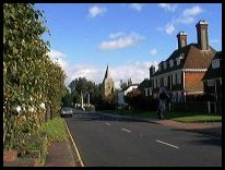
There are many interesting buildings in the beautiful
tree-lined high street of Burwash in East Sussex , some date from before
the 16th century. The Manor House of Burghurst stands
opposite the church.
In the 18th and 19th centuries Burwash was a haven for
smuggling , and one may note that several of the tombstones
in the churchyard bear the skull and crossbones.
The church of St Bartholomew was built in 1090 but
the tower is all that remains of the original Norman
structure. The church houses the rare 16th century
Geneva Bible, discovered in 1954 among a collection
of old books in the vestry of the church.
Also to be found in the church is a cast iron slab on
the wall by the Lady Chapel altar. It is 14th Century,
and used to be on the floor. It marked the resting
place of the local ironmaking family of Collins,
and it is believed to be the oldest example of a
Sussex grave slab. The churchyard has also some of
the Harmer terracotta gravestones from the early
19th century.
1721 brought excitement to the area as the Excise Men caught
up with Gabriel Tomkins leader of the Mayfield Gang of owlers
in the village, then chased him to Nutley where he was arrested.
Nearby is the market town of Heathfield , which along
with the surrounding villages of Waldron and Mayfield
was the centre of the Sussex iron industry in the 18th
century.
Burwash marks the northern boundary of ' 1066 Country '
being eight miles from Senlac field. A brown road sign
indicating the boundary. |
|
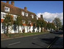 Burwash in East Sussex has some of the nicest views in the area. From the
church, the tree lined High Street is to the West. Burwash in East Sussex has some of the nicest views in the area. From the
church, the tree lined High Street is to the West.
Walk north from the Church to the junction with the Stonegate
road and you can see across the rolling Sussex hills to
Ticehurst and Flimwell.
Finally travel from the Church down to Kiplings home of Batemans,
and you can see the East Sussex countryside to its best effect. |
|
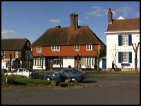 Burwash in East Sussex has a variety of shops, and public houses within
the village, providing the usual village fare. Burwash in East Sussex has a variety of shops, and public houses within
the village, providing the usual village fare.
The main shopping centre for Burwash is the small
town of Heathfield about 6 miles west. The nearest
large town shopping centres are in Hastings about
12 miles South East, and Tunbridge Wells 15 miles
to the North.
An infrequent bus service stops in the village and
travels to Heathfield and Hurst Green for further
connections.
The nearest train services are available from Etchingham three
miles to the east, or Stonegate about four miles north west. |
|
| Burwash is shown as the red symbol on the map. |
|
|
Nearby Villages
(click on symbol to see the village page) |
| Village= | |
Town= | |
Recorded in Domesday= |  |
| |
|
|
Bodiam |
(The finest ruined castle in the Country) | | 6.54 miles |
|
|
Brightling |
(famous for Mad Jack Fuller) | | 2.47 miles |
|
|
Broad Oak |
(Smallpox at the Academy) | | 4.68 miles |
|
|
Burwash Common |
(Roughest pub in the South East) | | 2.30 miles |
|
|
Burwash Weald |
(Roughest pub in the South East) | | 1.89 miles |
|
|
Cade Street |
(Jack Cade and the Kentish rebellion) | | 5.09 miles |
|
|
Cripps Corner |
(Home Guard surprises the Army) | | 6.63 miles |
|
|
Dallington |
(Custers Last Stand!) | | 3.84 miles |
|
|
Etchingham |
(The oldest Brass Weather Vane in the country) | | 2.32 miles |
|
|
Flimwell |
(300 local people beheaded) | | 4.62 miles |
|
|
Hawkhurst |
(A Notorious Gang of Smugglers) | | 6.25 miles |
|
|
Heathfield |
(19th Century Natural Gas) | | 6.19 miles |
|
|
Hurst Green |
(The Youngest Highwayman on record) | | 3.78 miles |
|
|
Mayfield |
(Saint Dunstan and the Devil) | | 5.71 miles |
|
|
Mountfield |
(17th Century Coal !!) | | 4.98 miles |
|
|
Netherfield |
(Village at the top of the Hill) | | 4.38 miles |
|
|
Punnetts Town |
(The Windmill on the Hill) | | 4.02 miles |
|
|
Robertsbridge |
(The Home of Modern Cricket) | | 3.81 miles |
|
|
Rushlake Green |
(Open Village and Nuclear Bunker) | | 5.06 miles |
|
|
Salehurst |
(Richard the Lion Heart's Gift) | | 4.50 miles |
|
|
Staplecross |
(Mothers grudge hangs son) | | 6.70 miles |
|
|
Stonegate |
(Ancient Roman Cross Road) | | 2.40 miles |
|
|
Ticehurst |
(Anne Boleyn and Pashley Manor) | | 3.41 miles |
|
|


